Prove ROI in 2–4 Weeks: Real Time Fleet Tracking for Truck & Civil

Real-time fleet tracking gives you live GPS positions, engine and driver telemetry, and instant alerts on every vehicle in your operation, updated as often as every few seconds. It replaces phone calls and guesswork with a dashboard that shows where every truck is right now, whether it’s idling, and when it will arrive. For fleet managers and operations leads, that means faster dispatch decisions, fewer “where’s my truck” calls, and a record you can trust for billing and compliance.
TL;DR:
- Fleet tracking systems that refresh every second provide more precise real-time data for high-value dispatch decisions versus standard plans updating every 30 to 60 seconds.
- Accurate map matching and reliable GPS signal are essential to prevent position jumping, especially in areas with tunnels or tall structures, and good engineering is key to recovering from tracking issues.
- Combining live GPS with vehicle health and driver behavior telemetry enables significant operational benefits such as faster dispatch, reduced idle time, and improved safety incident reconstruction.
- Integration of location data with compliance records, billing, and pre-start documentation streamlines admin tasks and speeds up invoice processing in truck and civil operations.
- Prioritizing update frequency, telemetry compatibility, API access, and compliance considerations is essential when choosing a fleet tracking system, starting with small pilots for effective rollout.
Table of Contents
- What Does Real-Time Fleet Tracking Actually Include?
- How Does Real-Time Tracking Get Data From Truck to Dashboard?
- What Operational Benefits Actually Show Up in the Numbers?
- How Do You Choose the Right Real-Time Fleet Tracking System?
- How Do You Roll Out Real-Time Tracking Without Losing Staff Buy-In?
- How Does a Specialised Truck and Civil Platform Integrate GPS Tracking?
- Does Real-Time Tracking Scale From Five Trucks to Fifty?
- Can You Track Your Fleet From a Phone, and Does It Work Offline?
- What Goes Wrong With Real-Time Fleet Tracking, and How Do You Fix It?
- Where Does Real-Time Fleet Tracking Deliver the Most Value?
- What Should You Actually Do With All This Tracking Data?
- Priority Features and Next Steps for Fleet Managers
- How Dirtchamp Supports Live Fleet Tracking for Truck and Civil Businesses
- Sources
- FAQ
What Does Real-Time Fleet Tracking Actually Include?
A genuine real-time system does more than drop a pin on a map. It combines location data with vehicle health, driver behaviour, and automated logic that reacts to what’s happening on the road.
The core building blocks look like this:
- Live GPS updates, refreshed anywhere from every second to every minute depending on the platform and plan. Enterprise systems built for high-value dispatch decisions can push updates as frequently as every second, while standard fleet plans typically refresh every 30 to 60 seconds, which is more than enough for most civil and trucking work.
- Telemetry beyond location, including fuel level, engine diagnostics, coolant temperature, harsh braking or acceleration events, and idle time. This is the data that turns a tracking map into an operations tool.
- Geofencing and automated alerts, so the system flags a vehicle entering or leaving a site, a depot, or a customer address, without anyone watching the map.
- Road snapping, also called map matching. Raw GPS coordinates are noisy, and without server-side correction a truck can appear to be driving through a paddock or a building. Practitioners who run high-volume fleets treat map matching as one of the least glamorous but most important engineering decisions in the whole system, because it’s what keeps a vehicle trace glued to the actual road network instead of jumping around the map.
Accuracy itself has a ceiling worth understanding before you set expectations with your team. Gps notes that civilian position accuracy depends on satellite geometry, receiver quality, and signal obstruction, which is why a truck under a bridge or between tall structures can briefly show a less precise position. Good map matching is largely what compensates for that gap in practice, snapping a slightly off coordinate back onto the road it’s actually travelling.
For a civil contractor, this combination matters more than raw location alone. Knowing a truck is at a site is useful. Knowing it’s idling there for 40 minutes with the engine running is what actually saves you money.
How Does Real-Time Tracking Get Data From Truck to Dashboard?
The trip from a vehicle’s engine bay to your screen involves three layers: the device, the connection, and the processing that turns coordinates into something usable.
- Device. Most fleets choose between a dedicated telematics unit wired into the vehicle, an OBD-II dongle that plugs into the diagnostics port, a driver smartphone app, or IoT sensors for trailers and equipment. Plug-in units suit fleets that want engine data without a workshop install; app-only setups can work where hardware cost is the bigger concern, since a driver’s phone alone can provide live position and status without any dedicated device.
- Connectivity. Devices transmit over a SIM data connection, and the platform either polls the device at intervals or receives a continuous stream. Streaming gives lower latency; polling is cheaper on data and battery, and most fleet platforms strike a balance depending on how time-critical the use case is.
- Server-side processing. This is where raw coordinates become useful. The platform runs map matching to snap positions onto roads, applies predictive models to calculate ETAs, and runs event detection to catch harsh braking, geofence breaches, or unusual idle time.
- APIs and webhooks. Integration is what connects tracking to the rest of your operation. Developer-facing platforms typically expose both streaming feeds for near real-time data and polling endpoints for historical backfill, which is how a tracking system feeds data into a TMS or a dispatch tool without manual re-entry. Webhooks let a geofence breach automatically trigger a text, an email, or a status update in another system.
The ETA calculation deserves its own mention. Modern predictive ETA doesn’t just measure distance and speed. It blends live GPS with current traffic conditions and historical route patterns, and Google’s own engineering explanation of this approach shows the same modelling reaching accuracy above 95% at scale. That’s the difference between telling a customer “the truck left an hour ago” and telling them “it will arrive at 2:47pm.”
Pro Tip: Ask any vendor demo to show you a live map-matching failure, like a truck near a tunnel or overpass. How the system recovers tells you more about engineering quality than any brochure.
What Operational Benefits Actually Show Up in the Numbers?
Live visibility only earns its cost when it changes what you do every day. The clearest wins show up in dispatch speed, fuel spend, customer communication, and safety.
- Faster dispatch and less idle time. Knowing exactly which truck is closest and free means fewer wasted trips and tighter route decisions, especially on multi-site civil jobs where reallocating a truck mid-morning can save an entire return trip.
- Fewer status calls. Giving customers a shareable tracking link instead of making them call for an ETA cuts the volume of “where is my delivery” enquiries that eat into an office team’s day, a pattern operators consistently report once customer-facing links go live.
- Safety and incident reconstruction. Continuous driver behaviour data, harsh braking, speeding events, sudden lane changes, gives you an evidence trail if an incident happens, rather than relying on memory or a dashcam that wasn’t recording.
- Maintenance and fuel gains. Continuous engine telemetry flags issues like excessive idling or early signs of mechanical strain before they become a breakdown on-site.
The 95% benchmark. Predictive ETA models that combine live GPS with traffic and historical patterns can reach accuracy above 95%. For a fleet manager, that’s the gap between a rough guess and an arrival time you can actually put in front of a customer.
None of these benefits require a fleet-wide rollout to prove themselves. A single high-traffic route or your busiest three trucks will show the pattern within a couple of weeks.
How Do You Choose the Right Real-Time Fleet Tracking System?
Picking a system is less about brand and more about matching capability to what your operation actually needs. Run through this checklist before you sign anything.
- Set your required update frequency and ask for the SLA in writing. A yard fleet moving between fixed sites might be fine with a 60-second refresh; a delivery fleet promising tight ETAs needs closer to real-time streaming.
- Confirm telemetry and sensor compatibility. Check the platform actually reads engine diagnostics, temperature sensors for refrigerated loads, door sensors, and tyre pressure monitoring if any of that applies to your trucks or trailers.
- Assess the integration routes. Look for documented APIs, webhook support, and data export options, not just a closed dashboard. If you already run a TMS or accounting software, ask specifically how position and event data flows across.
- Evaluate device management and installation effort. Wired telematics units need a workshop visit; OBD dongles and apps can often be self-installed. Factor this into rollout time, not just unit cost.
- Check the cost model. Some vendors charge per vehicle per month, others bundle hardware into a contract term. Work out the true cost over two to three years, not just the headline monthly figure.
- Review security, data retention, and workplace monitoring compliance. Ask how long location history is stored, who can access it, and whether the vendor’s defaults align with Australian guidance on workplace monitoring and surveillance. This isn’t a box-ticking exercise: getting it wrong creates real legal exposure and genuine employee pushback.
Treat this list as a specification document, not a wish list. Every vendor should be able to answer each point directly and specifically, not with a general capability statement.
How Do You Roll Out Real-Time Tracking Without Losing Staff Buy-In?
The technology rarely fails a fleet. Poor rollout does.
Start with a pilot, not a fleet-wide switch. Pick a small, representative sample, five to ten vehicles across your busiest routes, run it for two to four weeks, and measure specific things: dispatch response time, idle minutes per shift, and the number of status calls your office fields. That window is long enough to catch real patterns without dragging the decision out.
Driver and supervisor buy-in matters as much as the technology itself. Framing tracking purely as surveillance guarantees resistance; framing it as a tool that protects drivers (accurate hours, incident evidence, less blame for delays outside their control) tends to land better. Loop supervisors in early, since they’re the ones fielding questions on the ground.
- Set a clear, written policy on who can see what data and for how long, and be upfront with drivers about it.
- Use short-lived, secure geo-links for customer-facing tracking rather than granting broad external access to your live map, which keeps outside visibility limited to exactly what’s needed for that job.
- Test map matching specifically on your worst-signal routes (tunnels, dense industrial areas, remote sites) before you commit fleet-wide.
- Confirm SIM coverage across every region your trucks actually operate in, not just where head office is based.
Pro Tip: Before rollout, walk your own privacy policy against the OAIC’s workplace monitoring guidance. A five-minute check now avoids a much longer conversation with staff later.
How Does a Specialised Truck and Civil Platform Integrate GPS Tracking?
A specialised platform built for the truck and civil industry features an approach to GPS tracking tailored to that focus. Rather than treating location data as a standalone feature, it connects live tracking directly to pre-starts, dockets, and compliance records inside one platform.
That connection matters more than it sounds. When a truck’s location and site activity sit alongside its docket and compliance record, office staff aren’t chasing paper to match a job to an invoice. Billing gets faster because the record already exists.
Its tracking integrates via the vehicle’s OBD port without complicated installation work, which matters for operators who can’t afford to take trucks off the road for a full telematics fit-out. Supervisors get immediate visibility into where vehicles and machinery are, without waiting on a radio call or a text.
The operational pattern that shows up for most truck and civil businesses using this kind of integration includes faster invoicing because job and location data are linked, clearer site records for compliance audits, and less time spent on manual admin chasing paper trails.
Does Real-Time Tracking Scale From Five Trucks to Fifty?
Scalability isn’t really about how many dots a map can display. It’s about whether the underlying system holds up as data volume, users, and integration complexity grow.
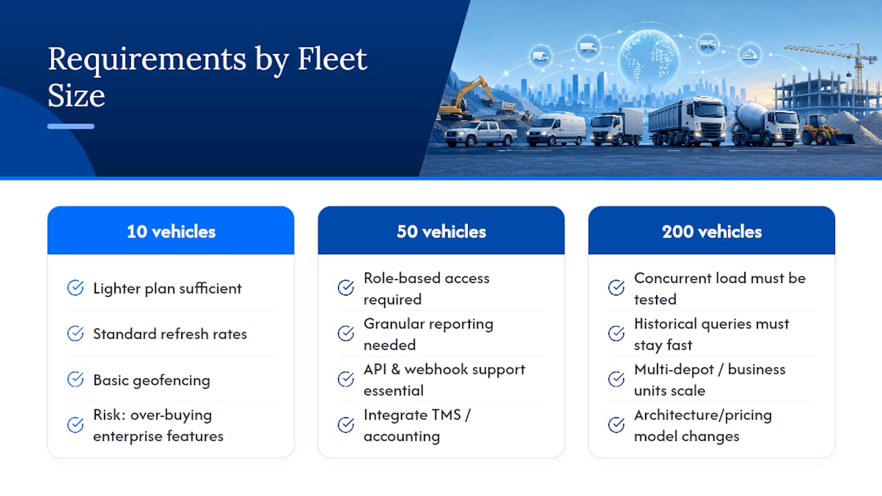
A small operation, say five to ten vehicles, can often run comfortably on a lighter plan with standard refresh rates and basic geofencing. The main risk at this size is over-buying: paying for enterprise-grade streaming and analytics you won’t use.
Mid-size fleets, in the 20 to 100 vehicle range, start needing role-based access (so a site supervisor sees only their trucks, not the whole fleet), more granular reporting, and integration with a TMS or accounting platform. This is where API access and webhook support stop being nice extras and start being essential.
Large or multi-site fleets need the system to hold up under concurrent load. That means checking how the platform performs when hundreds of vehicles are all reporting simultaneously, whether historical data queries stay fast as the dataset grows into years of history, and whether adding a new depot or business unit is a configuration change or a fresh implementation project.
The practical test is simple: ask a vendor to walk you through how their pricing and technical architecture change at 10 vehicles, at 50, and at 200. A platform that just multiplies a flat per-vehicle fee with no architecture conversation hasn’t actually thought about scale.
Can You Track Your Fleet From a Phone, and Does It Work Offline?
Mobile access is no longer optional. Supervisors and drivers expect the same live map on a phone that the office sees on a desktop, and most modern fleet tracking apps deliver exactly that, live positions, geofence alerts, and docket entry from a job site.
Offline capability is where apps genuinely differ, and it matters more in industries like civil construction where crews work in areas with patchy mobile coverage. A well-built app should let a driver complete a pre-start check or docket entry even with no signal, storing it locally and syncing automatically once connectivity returns. Without that, you lose records exactly in the locations where accurate records matter most, remote sites, quarries, regional routes.
Battery and data usage are the other practical concerns. An app pulling continuous high-frequency GPS and syncing large payloads over mobile data will drain a driver’s phone faster and chew through their data allowance, so look for adjustable update intervals and efficient sync behaviour rather than a fixed high-frequency setting with no options.
Test this properly before rollout, not after. Take a phone with the app installed into an actual dead zone on one of your regular routes, complete a docket or pre-start, and confirm it syncs correctly once signal returns. A vendor’s marketing claim about offline support means little until you’ve watched it happen on your own routes.
What Goes Wrong With Real-Time Fleet Tracking, and How Do You Fix It?
Most real-time tracking problems trace back to a handful of predictable causes, and most have straightforward fixes once you know what to look for.
Position jumping or vehicles appearing off-road almost always points to weak map matching, particularly in areas with tall buildings, tunnels, or dense tree cover that interfere with GPS signal. If this happens often on specific routes, raise it directly with your vendor. Persistent jumping on the same stretch of road usually means the underlying road network data needs updating, not that the hardware is faulty.
Delayed or missing updates are usually a connectivity issue rather than a tracking failure. Check SIM coverage on the specific route where it’s happening; regional and remote areas can have real gaps in mobile network coverage that no software fix will solve.
Inaccurate ETAs point to a modelling problem rather than a GPS problem. If a system isn’t factoring in live traffic and historical patterns for that route, ETAs will drift, particularly during peak periods or after roadworks change traffic flow.
Battery drain and data overuse on driver apps typically come down to update frequency set too high for the use case. Dialling back refresh rates on low-priority vehicles, while keeping high-frequency tracking on time-critical routes, usually solves this without sacrificing the visibility that matters.
Alert fatigue happens when geofences and event triggers are set too broadly, so supervisors start ignoring notifications altogether. Narrow the geofences and limit alerts to events that genuinely need action.
Where Does Real-Time Fleet Tracking Deliver the Most Value?
The core technology stays the same across industries, but the payoff looks different depending on what you’re moving and where.
For civil contractors and earthmoving fleets, the value sits in matching machinery and trucks to sites accurately for billing, and in proving compliance when a council or client asks for site activity records. Trucking and freight operators lean harder on ETA accuracy and customer-facing tracking links, since a huge share of daily admin in that sector is answering “where’s my load” calls.
Waste and utilities fleets use geofencing heavily, since route compliance (did every bin actually get collected, did every meter get checked) is often the entire point of the job. Field service businesses, plumbers, electricians, HVAC technicians, benefit most from live dispatch: knowing which technician is genuinely closest to a new job, not just which one was scheduled first thing that morning.
Refrigerated and cold-chain transport relies on temperature telemetry alongside location, since a late delivery matters less than a delivery that arrived warm. And quarry and materials haulage, close to Dirtchamp’s core audience, gets the clearest win from combining location with load and docket data, because that combination is what turns a truck movement into a billable, auditable record.
The common thread across every one of these is that raw location data on its own solves very little. Its value comes from what it’s paired with, whether that’s a temperature sensor, a docket, or a customer notification.
What Should You Actually Do With All This Tracking Data?
Collecting live location and telemetry is only half the job. The other half is turning that stream into reports that change decisions.
Look for a system that gives you trend reporting over time, not just a live map. Idle time by driver or vehicle over a month, fuel use trends against distance travelled, and geofence dwell time at customer sites all turn raw tracking data into something you can act on at a fleet level rather than a truck-by-truck level.
Exception-based reporting matters more than exhaustive dashboards. A report that flags only the three trucks with unusual idle time this week is more useful to a busy fleet manager than a 40-page summary of every vehicle’s every movement.
Exportable data matters too. If your platform’s analytics can’t feed into your existing accounting or payroll system, someone ends up re-entering numbers manually, which defeats a large part of the point of automating tracking in the first place. Check whether reports export cleanly to spreadsheet formats or connect via API to whatever system your office already relies on.
The best fleet performance reporting tends to answer three questions clearly: where is money being lost (idle time, fuel, detours), where is compliance risk sitting (missed geofence checks, expired certifications), and which trucks or drivers are consistently outperforming the fleet average. A dashboard that can’t answer those three plainly isn’t giving you performance data, just activity data.
Priority Features and Next Steps for Fleet Managers
If you’re shortlisting systems now, prioritise update frequency and integration capability above almost everything else. A beautiful dashboard with a 5-minute refresh delay is worse than a plain one updating every 30 seconds, because dispatch decisions live and die on how current the data actually is.
Start small. Run a pilot on one route or a handful of vehicles, and pair it with a customer-facing geo-link trial before committing fleet-wide. That combination tells you more in three weeks than any vendor demo will.
At procurement, ask three direct questions: what’s your map-matching failure rate on tunnels or dense urban routes, what does your API actually expose, and how does your workplace monitoring policy align with Australian privacy guidance. Vendors who answer specifically, rather than generically, are the ones worth shortlisting.
— Mike
How Dirtchamp Supports Live Fleet Tracking for Truck and Civil Businesses
If you’re running a truck and civil operation, generic fleet software forces you to bolt tracking onto systems that were never built for dockets, pre-starts, or compliance records in the first place. Dirtchamp was built the other way around: GPS tracking integrates directly into the same platform where your trucks, machinery, project records, and compliance documents already live, connected via the OBD port without a complicated install process.
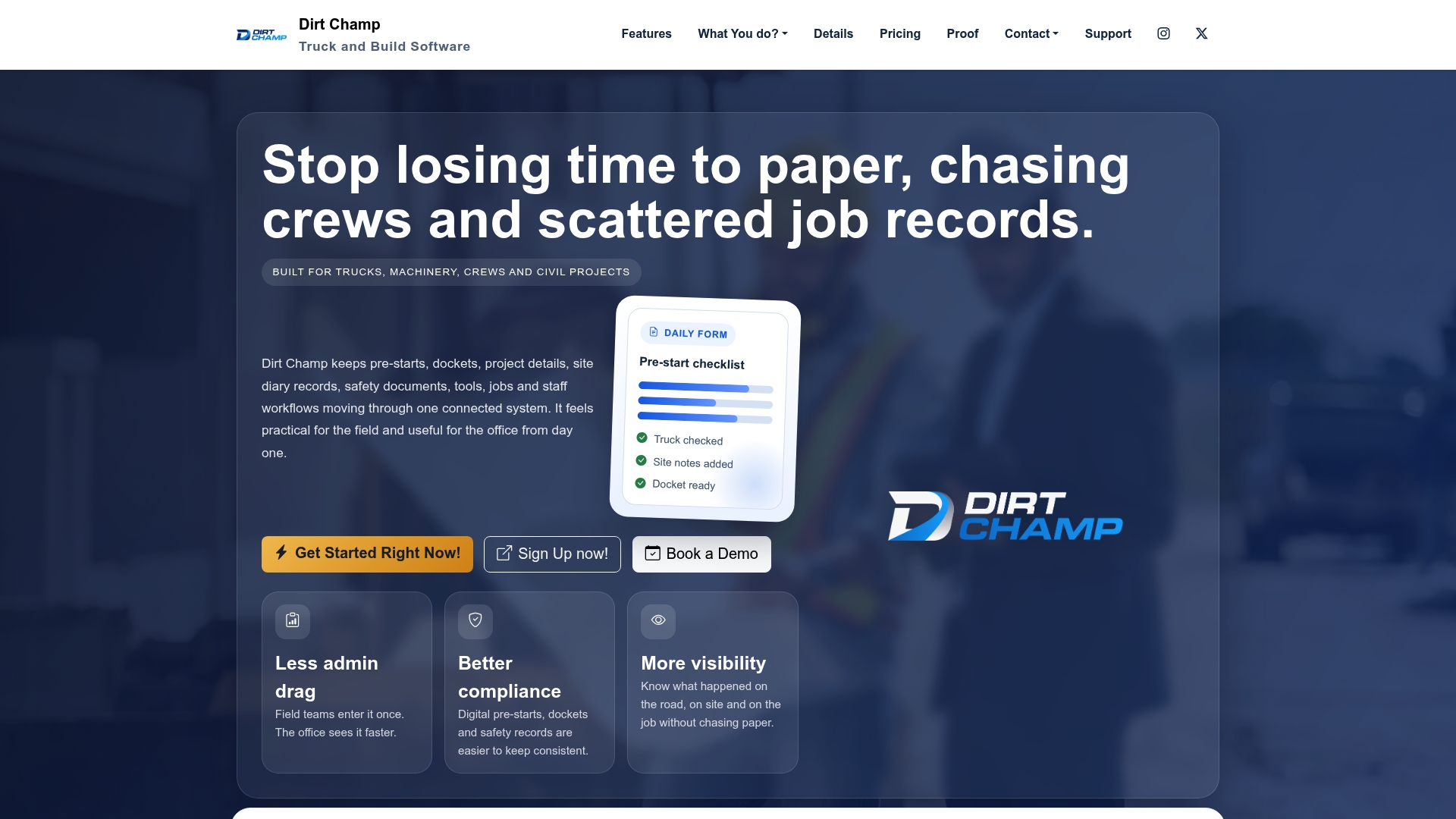
A demo typically walks through the live map alongside a real docket, a pre-start record, and a compliance snapshot, so you can see exactly how location data ties into billing and site records rather than sitting in a separate tracking app your office has to cross-reference manually. Supervisors get immediate visibility into where every truck and piece of machinery is, and admin teams get invoicing that doesn’t rely on chasing paper.
If your current setup means your trucks, your paperwork, and your compliance records all live in different places, it’s worth seeing how Dirtchamp brings them together in one view. Book a demo to see your own operation reflected on the platform before you commit to anything.
Sources
The accuracy and privacy claims in this article draw on national and government guidance rather than vendor marketing. GPS.gov’s performance and accuracy resource sets realistic expectations for civilian GPS precision. The OAIC’s workplace monitoring and surveillance guidance covers Australian privacy obligations for tracking deployments, and Google’s explanation of AI-driven traffic prediction outlines how predictive ETA modelling works at scale. For deeper reading on AI applications in adjacent safety technology, see this construction safety technology guide.
- Google Maps: how AI helps predict traffic and determine routes
- OAIC — workplace monitoring and surveillance
FAQ
How Can I Track My Fleet in Real Time?
You need a GPS-enabled device (a wired telematics unit, an OBD-II dongle, or a driver app) connected to a platform that processes and displays live positions on a dashboard. Platforms like Dirtchamp integrate this tracking directly with operational records like dockets and compliance documents, so location data feeds straight into billing rather than sitting in a separate system.
What Is the Best Real-Time Tracker for a Vehicle?
There’s no single best option. It depends on your fleet size, whether you need engine telemetry alongside location, and whether you want the tracking tied into broader operations software rather than running as a standalone app.
Is There a Real-Time GPS Tracker?
Yes. Most modern fleet tracking platforms offer near real-time updates, refreshing anywhere from every few seconds in enterprise systems to every 30 to 60 seconds on standard plans, well within the range needed for live dispatch decisions.
Is GPS Fleet Tracking Available in Australia?
Yes, GPS fleet tracking is widely available and used across Australian trucking and civil construction businesses. Deployments here need to follow Australian workplace monitoring and privacy guidance, particularly around informing staff how tracking data is collected, stored, and used.